

Most homeowners spend more time reading their cable bill than their land survey. That’s a problem. A survey is the legal backbone of every property transaction, and misreading it or ignoring it can cost you far more than you’d ever imagine once a deal goes sideways.
What Is a Property Survey and Why Does It Matter?
Do you actually know where your property ends and your neighbor’s begins? A land survey is a precise, licensed measurement of your property’s boundaries, structures, and physical features, translated into a scaled drawing you can actually hold in your hand. Surveyors collect field data using specialized equipment, then produce a plat, which is the recorded legal document that establishes exactly where your parcel of land begins and ends. Your plat gets filed with your county clerk and becomes part of the public record tied to your deed and ownership chain (and that chain matters at closing).
Why does this matter to a buyer or seller? Because every decision downstream, from financing to fencing to future development, rests on what that document says. Lenders often require a current survey before they’ll fund a purchase. Title companies rely on it to write insurance. And if a boundary question ever reaches an attorney’s desk, the survey is the first document they’ll pull.
I worked with a family in Mesquite last year, an elderly landowner whose adult children were splitting assets in a divorce and just wanted the sale handled without drama. The parcel sat along a creek, and nobody could agree on the rear boundary because the survey on file was decades old. On a Thursday morning, we sat down with the updated plat and settled it in under an hour, which I’ve found is pretty typical once everyone is looking at the same document. A current survey, clearly read, made a messy situation clean.
Texas rural land held a statewide median of $5,218 per acre in the second quarter of 2026, up 3.27% from a year earlier, which means property lines represent real money. Knowing what you own and being able to prove it (especially at closing) protects every dollar of that value.
If a property has boundary questions, an older survey, or other complications, a cash offer can provide a straightforward alternative to navigating every issue before selling. We Buy Land Quick can review your property, consider its condition and survey details, and make a cash offer with no pressure or obligation.
What Do All Those Lines, Numbers, and Symbols Mean?

Buyers who skip this section end up in closing meetings asking whether a fence they’ve been mowing around for years belongs to them. Misreading survey symbols is one of the quieter ways a real estate transaction gets complicated after the fact, turning small confusions on paper into real disputes at the table.
Every survey has a legend, and the legend is your decoder ring. Different land surveyors use slightly different symbology, so the only safe rule is to read that legend before you assume anything. A square symbol at a corner might mean a pin was found from a prior survey; a circle might mean a new pin was set. A found pin carries the weight of prior fieldwork, while a set pin reflects fresh measurements (and those two things aren’t interchangeable).
Bearing systems run on compass directions expressed as quadrant angles. “S 62° 30′ W” means you’d start facing south, rotate 62 degrees and 30 minutes toward west, and walk in that direction for whatever distance follows. Working your way around all four sides of a parcel using bearings and distances should return you exactly to your starting point. When it doesn’t, surveyors note the closure error, which is worth asking about if it’s large.
Right-of-ways appear as dedicated strips running along road frontage, often labeled “R/W” with a width measurement. You may own the land under that strip, but public or utility access rights override your ability to build there. Missing a road right-of-way means you’re planning on land you can’t use, which I’ve seen sink more than one addition or garage project well into the permitting process.
What Are the Key Components of a Survey Map or Plat?
You’re looking at your survey plat for the first time, and it feels like staring at an engineer’s homework. Start with these core elements, and the whole document opens up.
Bold boundary lines form the outer polygon of the plat, tracing the perimeter of your parcel. Along those lines, you’ll see bearings and distances: a notation like “N 45° E, 120.00′” tells you the direction and length of that particular boundary segment. These are the precise measurements that define your property’s dimensions on paper and in the field.
Monuments and markers appear at the corners as symbols, often small circles, squares, or crosses, each defined in the legend. They represent physical objects in the ground, iron pins, concrete monuments, or PK nails that a surveyor placed or located during fieldwork. Never assume a corner marker is where you think it should be until you’ve checked the survey, because I’ve seen pins buried under decades of mulch and sod that shifted the assumed boundary by several feet.
Easements are another layer entirely. Utility easements typically show as dashed or hatched strips with a label indicating their width and purpose. A notation like “10′ UE” marks a ten-foot utility easement, meaning a power or water company holds rights to that strip even though you own the land beneath it. Building setback lines appear as dashed lines inside the boundary and aren’t the same as the property line itself.
Finally, the title block, usually tucked in a lower corner, carries the surveyor’s license number, the fieldwork date, and a reference to the deed book where the original property description is recorded. The block ties the document to your legal ownership chain, which is exactly what a title company will check before they’ll insure anything.
If the survey has you wondering what your property is really worth, reach out to us. We can review the property details and provide a straightforward cash offer with no pressure or obligation. Contact us today to learn what your options look like.
How to Read a Land Survey Like a Real Estate Professional

For years, I thought reading a survey meant just finding the acreage number and moving on. That’s the wrong approach, especially when selling raw land, and I learned it the hard way when a utility easement I’d overlooked blocked a buyer’s plan to add a shop.
Start with the north arrow, because every directional measurement on the map is useless without it. Once you’ve oriented the plat, locate the Point of Beginning, the legal starting point for the property description. From there, trace the boundary line by line, matching each bearing and distance to the corresponding segment on the map.
Next, find every easement and right-of-way before you look at anything else inside the boundary. These are the hidden constraints that buyers consistently underestimate. A 20-foot drainage easement running diagonally across a backyard doesn’t show up in a listing photo, but it will absolutely show up in a survey, and it limits what you can build or plant there (fences included, from my experience).
Pay attention to the relationship between structures and boundary lines. The survey should show your house, driveway, and any outbuildings with dimensions indicating how far each sits from the nearest property line. A garage sitting two feet from the line might be perfectly legal, or it might violate a setback (I’ve seen this kill a closing), and that discrepancy can stall a sale.
When something doesn’t add up, call the surveying firm directly. Many surveyors are happy to walk a client through the document, and that conversation can save a transaction.
Common Survey Problems and How to Spot Them Early
A seller in Garland thought her property line ran along the back fence. The survey told a different story: the actual boundary was twelve feet behind the fence, and that gap belonged to her neighbor.
Fence lines are among the most common sources of confusion in real estate. Fences rarely follow property lines exactly, and decades of everyone assuming the fence is the boundary can create real legal headaches. The survey will show the fence as a physical improvement with a measured distance from the actual boundary (sometimes just inches off), not as the boundary itself.
Encroachments are another frequent problem. A driveway that extends onto an adjoining parcel, or a shed built over a property line, can bring a sale to a complete halt. Boundary disputes rank among the most litigation-prone categories of real property conflict in the country, and they often trace back to documents nobody bothered to read carefully at purchase.
Overlapping easements can quietly stack up on a single parcel. A property might carry a utility easement, a drainage easement, and an access easement granted to a neighboring parcel, all layered across a strip of land that looks, from the street, like a perfectly usable side yard.
Surveys recorded decades ago sometimes reference landmarks that no longer exist, and their measurements may not meet current precision standards. If the survey on file is more than ten years old, budget for a new one. The cost of updated fieldwork is consistently less than the cost of a boundary dispute reaching a courtroom. If you’re dealing with a property where boundaries or an outdated survey are complicating a sale, a cash land buyer in Plano and the surrounding cities in Texas may be worth considering.
How Surveys Affect Buyers, Sellers, and Property Decisions in North Texas
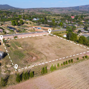
Sit down across from me at your kitchen table, and I’ll tell you this: the survey is the one document in your real estate transaction that doesn’t negotiate. Prices flex, and timelines shift, but survey data just is what it is.
Homes across the Dallas-Fort Worth metro sat a median of 54 days on the market in July 2026, and raw land usually takes longer, so buyers have more time for due diligence than they had a few years ago. That extra time should include a careful review of the property survey, not a quick skim, because boundary lines and easements buried in older documents can take weeks to properly research.
North Texas land carries survey complications you won’t see inside a platted subdivision. Long metes-and-bounds tracts split off old family farms, and the original calls can be hard to retrace. Creek and floodplain lines move over the years. Pipeline and utility corridors cross parcels where nobody expects them. An heir who received land from a grandparent may not realize that the back two acres carry a pipeline easement.
I had a situation in Denton involving an heir who received a job transfer and had five weeks to close out the estate and move. Going through the property files in the garage, we found a survey from the 1970s showing the driveway accessed a shared right-of-way with the neighboring lot. Nobody knew. The updated plat confirmed the easement was still active (a detail title company’s flag immediately). We factored it into the price, and the sale closed on time.
Land in Northeast Texas averaged $8,604 an acre in the second quarter of 2026. At that price point, a misread survey is not a minor inconvenience; it’s a title problem that can unwind months of work. If you’re dealing with a property that has complicated boundaries, old surveys, or easements, cash land buyers in Austin and other Texas cities can provide another option when you’re looking to sell without waiting through a traditional listing process.
Frequently Asked Questions
What Are Red Flags on a Survey?
Red flags include encroachments where a structure crosses onto a neighboring parcel, easements that cut through buildable areas, gaps between what the deed describes and what the survey shows, and monuments or pins that are missing or disturbed. An old survey with no fieldwork date, or one that references landmarks that no longer exist, is worth updating before you list or close.
What Do the Numbers Mean on a Land Survey?
Numbers along boundary lines represent two things: direction and distance. The bearing (such as N 30° E) tells you the compass direction of that line segment, and the number that follows (like 85.50′) tells you the length in feet. Numbers inside the boundary often indicate dimensions of structures, showing how far a building sits from the nearest property line. Your deed should reference the same bearings and distances you see on the survey.
How Do I Read and Interpret Survey Results?
Orient yourself with the north arrow first, then find the Point of Beginning and trace the boundary lines using the bearings and distances printed along each segment. Cross-reference every symbol against the legend, pay close attention to easement locations and widths, and compare the survey’s property description against your deed. If the two documents disagree, that discrepancy needs to go to an attorney or licensed surveyor before the transaction moves forward. Resources like your county clerk’s office can help you pull recorded plats and prior surveys on file.
Property decisions in North Texas move fast enough that survey confusion can cost you a sale. If you’ve got a parcel with complicated boundaries, an old plat, or easements you don’t fully understand, We Buy Land Quick works with properties in exactly that shape. No pressure to make a fast decision. If you want to talk through what you’re looking at and get a straight answer on what your land is worth, reach out to us at (469) 529-7977. We’re here for that conversation whenever you’re ready.
Helpful Texas Blog Articles